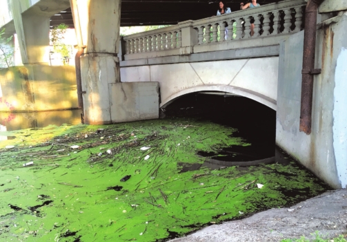
The Muddy River’s water quality improved by less than one percentage point this year, and the tributary remains the most polluted section of the Charles River.
The Charles River Watershed Association (CRWA) has released its annual river water quality report card, which averages water sample data over a three-year period to determine which sections of the river meet safe boating and swimming bacteria levels.
The Muddy River scored a grade of C, the same as it received last year, which is significantly worse than the rest of the Charles. It has improved from a D- in 2019, when the CRWA started issuing the report.
“The
Muddy River, the most polluted tributary, gets a C,” said Elizabeth
Norton, executive director of CRWA, in a speech at an event announcing
the report card in August. “That’s the one area we test that, literally
each year, we’re not seeing progress.”
The
tributary is so polluted because it is in a highly developed area when
compared to the rest of the Charles, said Marielena Lima, the river
science program manager for the CRWA. Since surfaces like concrete or
asphalt don’t absorb excess rainfall, all the water drains to the
tributary, which can cause sewage overflows.
“There’s
a lot of impervious surface, and so any rain that we have will
automatically funnel into the Muddy River,” Lima said. “The other big
thing is the hydrology of the Muddy River. It’s very man-made, very
altered for us to work around the river. That does have impacts on how
the water flows and the water quality.”
Lima
said the hydrology had recently improved, due to a project by the U.S.
Army Corps of Engineers completed in November. The $38 million project
dredged the tributary to increase how much rainfall it could absorb.
However, much work remains, as the river is still fed by polluted urban
rainfall and, in part, underground sewers.
The
lower basin of the Charles River, which includes the section that meets
Back Bay and Beacon Hill, scored a B- on the report card. This is
slightly worse than its score of B last year, which experts attribute to
the increased amount of rainfall.
“All
of the sites actually went down in grades slightly,” Lima said. “That’s
because this three-year average has two wetter years. The trend with
bacteria levels is that, when you have rainfall, that allows stormwater
runoff pollution to go into the river. Usually when it rains, if you
take a sample within 24 hours, you’ll see a higher bacteria level.”
The
lower basin’s grade, Norton said, means it is swimmable a little over
half the time. However, she noted, the section’s average grade does not
reflect the variation in water quality from one place to another. Some
locations have substantially improved, despite the overall score.
“There
are actually parts of the Charles in the Lower Basin that our data
show, near the Longfellow Bridge, that are swimmable virtually all the
time,” Norton said. “We think it's time to start having that
conversation about opening up areas for swimming.”
